Today I took myself off on a walk, following a route that I had never taken before 🙂
 I was able to do it with the help of ViewRanger and open street maps, using my iphone.
The walk had a dice with death start, as I had to cross the very busy A149 at the hospital roundabout, but I survived !!
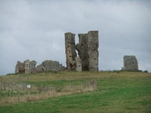
My route then took me up to the Ruined Church of St James Bawsey.
Through a pig farm, where the pigs paid an unhealthy interest in me 🙁
I then had to cross the A149 again making my way to Refley woods
ViewRanger then made it easy to find my way through the woods to Gaywood river, where I picked up the cycle path and walked home 🙂
A nice little walk, I really like knowing where I am all the time, which makes reading the Map easier, down side is the battery on the iphone soon runs down 🙁

Pleased you are enjoying the app (It`s a local Cambridge company) and that you are getting out and about. I’ve added a walk to OSM whilst I’m over in New Zealand. It’s good to know that you find OSM useful 🙂
just a shame the iphone battery goes flat so quickly…. but maybe by using this i will learn to read a real map lol lol